
Development of GML Map Visualization Service and POI Management Tool using Tagging
Jun. 2008. By Young-Sik Jeong
Keyword: GML, Map visualization, Hierarchical POI information management, Tagging, Dynamic map partition and caching
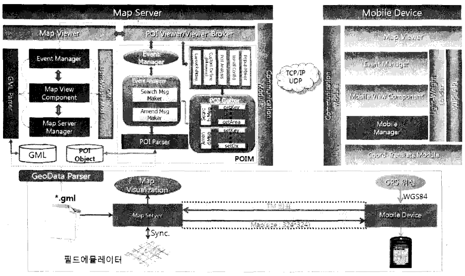
This research develops the GML Map Server which visualized the map based on GML as international standard for exchanging the common format map and for interoperability of GIS information. And also, it should transmit effectively GML map into the mobile device by using dynamic map partition and caching. It manages a partition based on the visualization area of a mobile device in order to visualize the map to a mobile device in real time, and transmits the partition area by serializing it for the benefit of transmission. Also, the received partition area is compounded in a mobile device and is visualized by being partitioned again as four visible areas based on the display of a mobile device. Then, the area is managed by applying a caching algorithm in consideration of repetitiveness for a received map for the efficient operation of resources. Also, in order to prevent the delay in transmission time as regards the instance density area of the map, an adaptive map partition mechanism is proposed for maintaining the regularity of transmission time. GML Map Server can trace the position of mobile device with WIPI environment in this research. The field emulator can be created mobile devices and mobile devices be moved and traced it's position instead of real-world. And we developed POIM(POI Management) for management hierarchically POI information and for the efficiency POI search by using the individual tagging technology with visual interface.